![]()


A social-ecological framework for sustainable landscape planning – Case studies from the Wet Tropics of Far North Queensland
CSRIO Sustainable Ecosystems, Tropical Forest Research Centre, PO Box 780, Atherton 4883 Queensland, ph. + 61 7 4091 8826. http://www.cse.csiro.au/research/landscapescenarios/ Email: iris.bohnet@csiro.au
It is increasingly recognised that participation by local people (including farmers, industry representatives, interest groups, and decision-makers) in landscape and natural resource management (NRM) planning is important in creating sustainable landscapes. Mechanisms that facilitate communication between scientists, planners, government, and local people are essential to participation. Over the last decade, a wide range of communication and participatory tools and processes, such as scenario techniques, discussion groups and information campaigns, have been developed to engage local people in planning processes. However, the issues of when and how communication and participation by local people should take place to achieve a multitude of goals, including social learning and building capacity to deal with change, are unclear. To address this issue, a social-ecological framework for sustainable landscape planning has been developed and tested in two case studies in the Wet Tropics. The framework establishes mechanisms for meaningful participation throughout the different stages of the planning process. A range of participatory tools and processes, specific to each stage of the research, have been combined including qualitative interviews, landscape scenario visualisations and community workshops. Evidence from the case studies suggests that while the implementation of the social-ecological framework is able to achieve a multitude of goals, it also provides a number of new challenges, which will be briefly discussed in this paper.
Planning for a sustainable future
A new social-ecological framework developed by CSIRO scientist Dr Iris Bohnet demonstrates the multiple values of community participation in planning for a sustainable future.
Key words
Landscape planning, participatory approaches, social-ecological framework, sustainable future, community development
Introduction – community participation in landscape and NRM planning
Since the 1990s there has been growing recognition of the value of participation by local people in landscape and NRM planning (Luz 2000, Department of Natural Resources and Mines, 2005). In Australia, this has led to increasing government support for regional communities to take responsibility for managing natural resource issues through planning, investment and action. This regional approach to NRM is based on some fundamental assumptions:
- large-scale change is more likely to occur when local people are responsible for NRM planning and management;
- a regional approach to NRM can draw on and use the capacity of people closest to the issues more efficiently than a state-wide approach; and
- local and regional groups are perfectly placed to engage with landholders and industry sectors, to raise awareness about sustainable landscape management and to support on-ground work.
To implement the regional approach to NRM planning, the Australian government established 14 incorporated community-based regional NRM bodies in Queensland over the past three years and assisted these groups to develop NRM plans and investment strategies for their regions. NRM facilitators and coordinators have been employed to achieve a high level of community information and participation to support the NRM plans through community workshops, community information sessions and a number of fora (FNQ NRM Ltd & Rainforest CRC, 2004). Now the regional NRM groups are focusing on implementing the plans over the next few years, working in close collaboration with local councils, research providers, industry representatives, landholders, conservation and catchment groups, indigenous groups, and local organisations such as Landcare, Bushcare, Coastcare and Waterwatch. Although community participation in the regional approach to NRM must continue to advance, it is even more important to break new ground at the local level where plans get implemented and people are directly affected by the decisions made, as well as to touch on questions of how and when meaningful participation by local people in planning processes should take place to achieve a multitude of goals, including social learning and building capacity to deal with change.
A social-ecological framework for sustainable landscape planning
To address the issues of community participation in local planning and how and when community participation in planning processes may be most effective, a social-ecological framework for sustainable landscape planning has been developed (Figure 1) and tested in two case study areas in the Wet Tropics (Bohnet, 2004). The framework is based on the idea that landscape is about the relationship between people and place (Tress and Tress, 2001). To make this concept of landscape operational, landscape is studied in subsystems or different dimensions: the natural and cultural dimension, the visual, socio-cultural and economic dimension (Figure 1). The framework shares many aspects with existing planning frameworks (Botequilha Leitao and Ahern, 2002) however, it includes communication as a task to be undertaken as seriously as desk and field studies throughout the research. Thus, the framework allows the incorporation of participatory tools, such as landscape visualisations (Schmid, 2001), and processes, such as community workshops (Hulse et al., 2004).
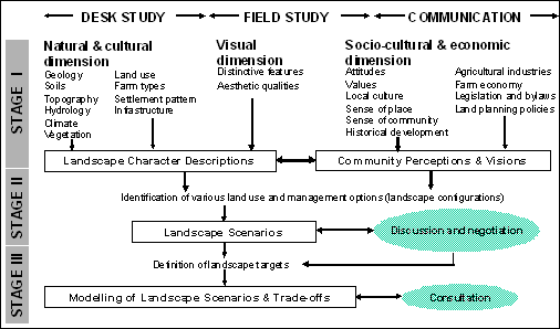
Figure 1: Social-ecological framework for sustainable landscape planning (Source: Bohnet, 2004).
In the proposed three staged planning process, opportunities and mechanisms for meaningful participation are established. In each stage of the research, different sets of methods–tools and processes–can be applied. The tools refer to methods used to collect data; processes refer to participatory approaches; both are strategically employed to achieve multiple goals. For example, in Stage 1 of the research, qualitative interviews with landholders may be used to collect data on landholders’ perceptions, values, interests and needs but also to establish trust between landholders and the scientist working on the project. The tools and processes are not explicitly named in the framework to allow for maximum flexibility of methods and approaches to be combined and applied in a situation specific manner. Swanwick et al. (2002, p.6) state:
“Deciding in principle to involve stakeholders is only the first step. Decisions must be made about which stage, or stages, of work they will participate in and how this will be achieved. Few projects are likely to be able to achieve major stakeholder participation at all stages of the research process, but it is important to find the best ways of involving stakeholders within the available time and resources.”
In the social-ecological framework proposed here, community involvement is recommended throughout the research, with different participatory tools and processes being suggested for the three different stages in conjunction with desk studies and field studies (Bohnet, 2004). These activities (desk studies, field studies and communication) have been included as separate tasks, as communication and participation in planning has often been neglected or added-on at the end of the planning process when it has been too late for communication or participation to be effective.
The three stages of the research are briefly discussed in the following section, focusing on the participatory tools and processes employed in the Mossman and Julatten case studies (Bohnet, 2004). The process is not unidirectional as shown in Figure 1; there are feedback loops and reasons for iterative processes in the different stages of the research. It may even be necessary to go back to the previous stage, if, for example, desired outcomes on which landscape scenarios have been based cannot be achieved.
Stage 1
To assess local attitudes towards landscape, environmental values and the economic situation of farmers in the case study areas, qualitative interviews with a wide range of farmers and land managers in the Mossman and Julatten landscape were carried out in 2003 (Bohnet, 2004). Based on the analysis of the interview data, social profiles were developed, describing the people, their land use and management practices, landscape and environmental values, and their future goals and aspirations regarding the development of their land and the landscape of their local area. Together with desk studies (literature and spatial data reviews) and field studies (landscape assessments), the interviews provided detailed information that was used as a foundation for Stage 2. A less tangible goal was also to establish a personal relationship and trust with some key stakeholders in the area.
Stage 2
The landscape character descriptions provided the basis to select landscape photographs of Mossman and Julatten reflecting their particular characters. Based on the interviewees’ ideas and visions for the future, the selected landscape photographs were manipulated through changes in land use and management practices (Figure 2). The landscape visualisations were used as a tool to stimulate public debate about future landscape developments and to invite the wider community to take part in a ‘futures workshop’. These workshops broadened the scope of the research by including other interest groups apart from farmers and land managers in the development of future visions. The workshops were a participatory planning tool to gather a wide range of local views regarding desired future landscape developments and as a process enabling participants to learn about complex planning issues in a group and to build their own capacity, including skills, expertise and awareness.

Figure 2: Landscape visualisations of Julatten. Left – Landscape in 2003. Middle – Agriculturally diversified landscape in 2025. Right – Post-sugarcane landscape in 2025. (Source: Bohnet, 2004).
Stage 3
Workshop participants based their visions for the future on landscape targets/goals, which they discussed and negotiated in the workshops. They provided the foundation for creating spatially explicit landscape scenarios in a Geographic Information System (GIS). Current land use and management practices were used as baseline information to develop the community driven landscape scenarios. The scenarios were visualised and a Landscapes Toolkit (LsT) is being developed to assess the environmental, social and economic values of the different scenarios (Roebeling et al., 2005). In future, it is anticipated that the scenario maps and the LsT could be used in discussions about trade-offs between different options with local communities. This process is considered to provide additional opportunities for local people to discuss and evaluate potential futures and their trade-offs and to make more informed decisions about the future.
Discussion
The overall response gathered from the participants of this research was very positive. Farmers and land holders who were interviewed and their farm landscape assessed in Stage 1 were surprised and impressed by the participatory approach taken. Their previous experience with scientists and extension personnel coming to their farms was often overshadowed by the fact that they were mainly told what to do instead of being considered a ‘research partner’ and the advice that was given to them was frequently contradictory. As land owners or managers they felt responsible for the management of their land and therefore appreciated that their views were considered important and taken into account when planning for the future. Participants of the ‘future workshops’ appreciated that they were given the opportunity to present their views and to be able to discuss with other members of the community their thoughts on future developments of their area. The workshops were an enjoyable, educational and social event for many participants, which in some instances provided the chance to break the ice between different groups through discussing issues that were close to their hearts. Participants also welcomed the idea that their visions for the future provided the basis to develop spatially explicit landscape scenarios that would be used to analyse environmental, social and economic values. However, one of the main questions raised by participants at the beginning of the workshops was: “will our ideas and suggestions be taken forward and be considered by local government planners?” and if so: “how will our views be integrated in a new local planning scheme?” These questions came as no surprise; however, they are not easy to answer and genuine research projects like the one presented here may run the risk of being considered ‘a nice scientific exercise’ to progress our science in the field of participatory research, without having real world implications. This is of course one of the key motives for people taking part in participatory research as they want to change the status quo or want to contribute to making a difference.
Conclusion
The strategically employed participatory tools and processes, used in the Mossman and Julatten case studies, as part of the social-ecological framework, have contributed to the empowerment of local communities, a better understanding of complex issues related to planning, and improved the community’s capacity to plan for the future and to manage change. Despite acknowledgment and support from governments for capacity building initiatives, the value of community participation in landscape planning has not been fully recognised yet. To increase government support for community participation in local planning, further research will be needed to demonstrate the values inherent in participation. These are difficult to measure and evaluate qualitatively as well as quantitatively and are highly likely to be long-term. Furthermore, as social scientists and practitioners in the field we have to tackle issues related to progressing and advocating participatory science on the one hand and expectations when carrying out on-ground applications on the other. Related to these issues is the need to further develop and test participatory theories and methods in order to achieve multiple practical long-term outcomes for our participants. However, our research efforts will fail to be fully appreciated by local communities until participatory research approaches are institutionalised and become a formal part of local government planning. Then communities will see the adoption of their ideas and views.
References
Bohnet, I. 2004. Agricultural landscapes in the Wet Tropics: Future visions balancing environmental, social and economic needs. CSIRO Sustainable Ecosystems, Atherton, Australia. Accessible from: http://www.cse.csiro.au/research/landscapescenarios/
Botequilha Leitao, A. and J. Ahern. 2002. Applying landscape ecological concepts and metrics in sustainable landscape planning. Landscape and Urban Planning 59, 65-93.
Department of Natural Resources and Mines. 2005. Options for future community engagement in regional natural resource management. Queensland Government, Brisbane.
FNQ NRM Ltd & Rainforest CRC. 2004. Sustaining the Wet Tropics: A Regional Plan for Natural Resource Management 2004-2008. Draft for Public Comment. FNQ NRM Ltd, Innisfail (240pp).
Hulse, D. W., Branscomb, A. and S. G. Payne. 2004. Envisioning Alternatives: Using citizen guidance to map future land and water use. Ecological Applications 14, 325-341.
Luz, F. 2000. Participatory landscape ecology - A basis for acceptance and implementation. Landscape and Urban Planning 50, 157-166.
Roebeling, P.C., Bohnet, I., Smith, M., Westcott, D., Kroon, F., Hartcher, M., Hodgen M. and J. Vleeshouwer. 2005. Landscapes Toolkit for triple-bottom-line assessment of land use scenarios in Great Barrier Reef catchments. MODSIM conference, Melbourne December 2005, Australia.
Schmid, W. 2001. The emerging role of visual resource assessment and visualisation in landscape planning in Switzerland. Landscape and Urban Planning 54: 213-221.
Swanwick, C., Bingham, L., and A. Parfitt. 2002. Topic paper 3: Landscape Character Assessment how stakeholders can help. Landscape Character Assessment - Guidance for England and Scotland. The Countryside Agency and Scottish Natural Heritage.
Tress, B. and G. Tress. 2001. Capitalising on multiplicity: a transdisciplinary systems approach to landscape research. Landscape and Urban Planning 57, 143-157
![]()
