
|
First National Conference on the Future of Australia's Country Towns |


What is happening in rural and regional populations?
- Introduction
- Defining Non-Metropolitan Areas
- Population Trends In Non-Metropolitan Australia
- Processes Of Population Change In Non-Metropolitan Australia
- Changing Patterns Of Age Structure In Non-Metropolitan Australia
- Changing Employment Patterns In Non-Metropolitan Australia
- Changing Social Characteristics Of Australia's Non-Metropolitan Population
- Conclusion
- References
Professor of Geography, University of Adelaide
Introduction
There are many myths which have been perpetuated about non-metropolitan Australia but among the least tenable is the stereotyping of these areas as being less dynamic and less differentiated than the nation's metropolitan areas. The present paper seeks to dispel this myth by examining some of the contemporary dynamics of the non-metropolitan sector through the window of considering the shifts in its population. The 37.3 percent of Australians living outside of cities with more than 100,000 inhabitants are changing in substantial and important ways under the influence of economic, social, political and environmental changes. The people of the sector are its most important resource yet, while the dynamics of population change in the metropolitan sector are well known, that occurring in non-metropolitan Australia has not been analysed to the same extent. The present paper seeks to summarise trends in the size, composition and spatial distribution of Australians living outside the major cities. At the outset, however, it is necessary to address some definitional issues.
Defining Non-Metropolitan Areas
With the burgeoning of interest in regional issues in Australia there has been a great deal of confusion about who should be included in considerations of regional Australia. Part of the confusion has arisen from a lack of conceptual clarity. Terms such as regional, rural and remote are employed sometimes with a specific meaning and in other cases more vaguely. Much of the present confusion regarding rural, remote and regional stems from an attempt to combine into a single classification two distinctly different conceptual elements:
- urban/rural
- accessibility/remoteness
It is argued here that these are quite different concepts and need to be treated as such in differentiating types of settlement. An area can be both urban and remote or rural and remote. Any attempt to classify non-metropolitan Australia into rural and remote areas is misplaced. We need to classify areas in terms of their urbanness/ruralness and we also need to classify them by their degree of remoteness. The Australian Standard Geographical Classification (ASGC) already has a system of identifying and classifying urban and rural areas and it is argued that this system needs to be maintained albeit slightly modified. On the other hand, it is also suggested that there is a need for an additional classification of accessibility/remoteness which allows areas outside of the major cities of the nation to be classified according to their degree of accessibility to services. Such a classification, known as ARIA (Accessibility/Remoteness Index of Australia), has been developed in the National Key Centre for Social Applications of Geographical Information Systems (GISCA) located at the University of Adelaide (Bamford et al. 1999).
The definitions employed in this paper can be clearly stated. The term non-metropolitan is used to refer to all parts of the country outside of centres with more than 100,000 inhabitants. Within these areas two types of differentiation are made. Firstly in accordance with the Australian Standard Geographical Classification (ASGC) `Sections of State' are recognised as follows:
- Major Urban - urban areas (Urban Centres in the UC/L Structure) with a population of 100,000 and over.
- Other Urban - urban areas (Urban centres in the UC/L Structure) with a population of 1,000 to 99,999.
- Bounded Rural Locality - rural areas (Localities in the UC/L) with a population of 200-999 population.
- Rural Balance - the remainder of the S/T.
- Migratory - areas composed of offshore, shipping and migratory CDs.
However, the paper also differentiates within non-metropolitan areas according to their degree of remoteness. ARIA indices of remoteness have been calculated for 11,338 localities outside of Australia's major cities and the entire area of non-metropolitan Australia has been classified into five categories of remoteness:
- Highly Accessible - locations with relatively unrestricted accessibility to a wide range of goods and services and opportunities for social interaction.
- Accessible - locations with some restrictions to accessibility of some goods, services and opportunities for social interaction.
- Moderately Accessible - locations with significantly restricted accessibility of goods, services and opportunities for social interaction.
- Remote - locations with very restricted accessibility of goods, services and opportunities for social interaction.
- Very Remote - locationally disadvantaged - very little accessibility of goods, services and opportunities for social interaction.
The distribution of these five types of areas is depicted in Figure 1.
Figure 1: Accessibility/Remoteness Index of Australia (ARIA) 1996
ARIA index values interpolated to 1 km grid
| |
ARIA categories | |
|
Remote |
Source: Glover, Harris and Tennant 1999, p. 9 | |

Population Trends In Non-Metropolitan Australia
In this section we will examine the extent to which Australia's non-metropolitan population has changed over the last three decades. This will be undertaken from a number of viewpoints. One perspective is provided in Table 1 which addresses directly the focus of this meeting - Country Towns. This shows that over the period that the present definition of urban centres has been applied that the number of non-metropolitan1 urban places (i.e. country towns) has proliferated from 450 in 1966 to 728 in 1996. Country towns have increased their share of the national population from 20.5 percent in 1966 to 23.7 percent in 1996. Indeed, if one includes the large provincial centres with between 100,000 and 499,999 inhabitants in this category the increase is even more marked - from 25.9 to 32.9 percent. It may come as a surprise to some that almost one-quarter of Australians live in country towns and regional centres.
Another perspective is provided if we examine the `Section of State' statistics referred to in the previous section. Figure 2 shows the changes which occurred in the proportions living in metropolitan and non-metropolitan areas over the twentieth century. The long-term tendency toward increasing concentration of the Australian population is in evidence. There is a consistent pattern of urban areas increasing their share of the total population up to 1976. At the 1933 census, 37.4 percent of Australians lived in rural areas but by 1961 this proportion had halved and in 1976 only 13.9 percent of the population was classified as rural. The pattern was, however, not just one of concentration in urban centres but of a growing dominance of the largest metropolitan centres. Indeed, the non-metropolitan share of the total national population progressively declined in the half century following 1921 from 57 to 36 percent so that by 1971 nearly two-thirds of all Australians lived in the large metropolitan capital cities. Between 1971 and 1976, however, the proportion living in rural areas continued to decline (albeit marginally) but there was also a decline in the metropolitan area's share of the total national population. Hence in the early 1970s the only sector to gain ground was that of the non-metropolitan urban centres. It is apparent from Figure 2 (and Table 2 which indicates the numbers living in the various section of state categories at recent censuses) that over the subsequent period there has been a relative stability in the proportions of Australians living in major urban
Table 1: Distribution of Population by Settlement Size, 1966, 1971, 1976, 1981, 1986, 1991 and 1996
Settlement Size |
Number of urban centres |
Percentage of population | ||||||||||||
1966 |
1971 |
1976 |
1981 |
1986 |
1991 |
1996 |
1966 |
1971a/ |
1976 |
1981 |
1986 |
1991 |
1996 | |
500,000 and over |
5 |
5 |
5 |
5 |
5 |
5 |
5 |
56.0 |
57.9 |
57.0 |
55.5 |
54.5 |
53.3 |
53.1 |
100,000 - 499,999 |
4 |
5 |
6 |
8 |
7 |
8 |
8 |
5.4 |
6.6 |
7.5 |
8.9 |
8.2 |
9.1 |
9.2 |
75,000 - 99,999 |
1 |
1 |
1 |
1 |
1 |
2 |
0.8 |
6.5 |
0.6 |
0.7 |
0.6 |
0.5 |
1.0 | |
50,000 - 74,999 |
5 |
5 |
6 |
9 |
7 |
6 |
6 |
2.4 |
2.5 |
2.5 |
3.8 |
2.8 |
2.2 |
2.1 |
25,000 - 49,999 |
5 |
12 |
13 |
12 |
11 |
17 |
25 |
1.5 |
3.2 |
3.1 |
3.2 |
2.3 |
3.3 |
4.6 |
20,000 - 24,999 |
11 |
8 |
6 |
12 |
22 |
22 |
17 |
2.1 |
1.4 |
0.9 |
2.1 |
3.1 |
2.9 |
2.1 |
15,000 - 19,000 |
17 |
16 |
19 |
21 |
17 |
14 |
14 |
2.5 |
2.2 |
2.5 |
2.9 |
1.9 |
1.5 |
1.3 |
10,000 - 14,999 |
19 |
22 |
22 |
17 |
29 |
36 |
37 |
2.0 |
2.0 |
2.0 |
1.7 |
2.2 |
2.5 |
2.5 |
5,000 - 9,999 |
61 |
66 |
73 |
84 |
83 |
89 |
86 |
3.8 |
3.7 |
3.9 |
4.9 |
3.8 |
3.7 |
3.5 |
2,500 - 4,999 |
103 |
110 |
115 |
122 |
127 |
153 |
165 |
3.1 |
3.0 |
2.9 |
3.3 |
2.7 |
3.1 |
3.2 |
2,000 - 2,4999 |
50 |
52 |
56 |
59 |
71 |
75 |
64 |
1.0 |
0.9 |
0.9 |
1.0 |
1.0 |
1.0 |
0.8 |
1,000 - 1,999 |
178 |
180 |
181 |
213 |
252 |
280 |
312 |
2.2 |
2.0 |
1.9 |
2.4 |
2.2 |
2.3 |
2.5 |
Total urban |
459 |
481 |
503 |
563 |
632 |
706 |
741 |
82.9 |
85.6 |
86.0 |
85.7 |
85.4 |
85.1 |
86.0 |
Total rural |
16.9 |
14.3 |
13.9 |
14.2 |
14.5 |
14.8 |
14.0 | |||||||
Total populationb/ |
100.0 |
100.0 |
100.0 |
100.0 |
100.0 |
100.0 |
100.0 | |||||||
Total number (`000) |
11,599 |
12,756 |
13,548 |
14,576 |
15,602 |
16,851 |
17,892 | |||||||
Source: Rowland 1982, ABS Censuses 1981-1996
a/ Figures not corrected for under enumeration.
b/ Includes migratory population.
Table 2: Australia: Population Growth by Section of State, 1954-96
Source: Bowie 1987; ABS 1976, 1981, 1986, 1991 and 1996 Censuses
Census Year |
Metropolitan (Major urban) Number |
% |
Non-Metropolitan Number |
% |
Other Urban Number |
% |
Rural Number |
% |
Australia Number |
% |
A. |
||||||||||
1954 |
4,813,121 |
53.6 |
4,173,409 |
46.4 |
2,214,280 |
24.6 |
1,959,129 |
21.8 |
8,986,530 |
100.0 |
1961 |
5,885,121 |
56.0 |
4,623,065 |
44.0 |
2,696,147 |
25.7 |
1,926,918 |
18.3 |
10,508,186 |
100.0 |
1966 |
6,730,663 |
58.0 |
4,871,231 |
42.0 |
2,887,299 |
24.9 |
1,983,932 |
17.1 |
11,601,894 |
100.0 |
1971 |
7,695,194 |
60.4 |
5,094,444 |
39.6 |
3,184,617 |
25.0 |
1,864,827 |
14.6 |
12,744,638 |
100.0 |
1976 |
8,093,138 |
59.7 |
5,454,820 |
40.3 |
3,532,868 |
26.1 |
1,921,952 |
14.2 |
13,547,958 |
100.0 |
1981 |
9,202,318 |
63.2 |
5,364,012 |
36.8 |
3,287,438 |
22.6 |
2,063,600 |
14.2 |
14,576,330 |
100.0 |
1986 |
9,817,933 |
633.0 |
5,765,875 |
37.0 |
3,499,012 |
22.5 |
2,266,863 |
14.5 |
15,583,808 |
100.0 |
1991 |
10,563,364 |
62.7 |
6,278,205 |
37.3 |
3,776,550 |
22.4 |
2,501,655 |
14.9 |
16,841,569 |
100.0 |
1996 |
11,221,393 |
62.8 |
6,659,821 |
37.2 |
4,161,498 |
23.3 |
2,498,323 |
14.0 |
17,881,214 |
100.0 |
B. |
||||||||||
1976 |
8,654,328 |
63.9 |
4,900,703 |
36.1 |
2,997,043 |
22.1 |
1,888,602 |
13.9 |
13,555,031 |
100.0 |
1981 |
9,202,318 |
63.2 |
5,364,012 |
36.8 |
3,287,438 |
22.6 |
2,063,600 |
14.2 |
14,566,330 |
100.0 |
1986 |
9,817,933 |
62.9 |
5,784,223 |
37.1 |
3,517,360 |
22.5 |
2,266,863 |
14.5 |
15,602,156 |
100.0 |
1991 |
10,461,964 |
62.1 |
6,338,576 |
37.9 |
3,877,950 |
23.0 |
2,510,626 |
14.9 |
16,850,540 |
100.0 |
1996 |
11,221,393 |
62.7 |
6,671,030 |
37.3 |
4,161,498 |
23.3 |
2,509,532 |
14.0 |
17,892,423 |
100.0 |
Percent Change |
||||||||||
A. |
||||||||||
1954-61 |
22.3 |
10.8 |
21.8 |
-1.6 |
16.9 |
|||||
1961-66 |
14.4 |
5.4 |
7.1 |
3.0 |
10.4 |
|||||
1966-71 |
14.3 |
3.7 |
10.3 |
-6.0 |
9.8 |
|||||
1971-76 |
5.2 |
8.0 |
10.9 |
3.1 |
6.3 |
|||||
1976-81 |
5.0 |
11.5 |
12.9 |
9.0 |
7.6 |
|||||
1981-86 |
15.6 |
-5.2 |
-12.2 |
8.2 |
6.9 |
|||||
1986-91 |
7.6 |
8.9 |
7.9 |
10.4 |
8.1 |
|||||
1991-96 |
6.2 |
6.1 |
10.2 |
-0.1 |
6.2 |
|||||
B. |
||||||||||
1976-81 |
6.3 |
9.5 |
9.7 |
9.3 |
7.5 |
|||||
1981-86 |
6.7 |
7.8 |
6.4 |
9.8 |
7.1 |
|||||
1986-91 |
6.6 |
10.4 |
10.3 |
10.8 |
8.0 |
|||||
1991-96 |
6.2 |
4.4 |
7.3 |
-0.04 |
6.2 |
Note: A. Each section of state as defined in the report of each census.
B. Based on the section of state as defined in the report of the 1981 census. Non-major urban includes migratory population.
 Figure 2: Australia: Changing Distribution of Population Between Metropolitan, Other Urban and Rural Sectors, 1921-96
Source: Australian Censuses 1921-96
areas and indeed there has been a consistent decline in the proportion of Australians living in the largest five capitals (Sydney, Melbourne, Brisbane, Perth and Adelaide) from 57.9 percent in 1971 to 53.1 percent in 1996.
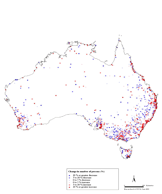
However, this change has not been a renaissance of population growth throughout non-metropolitan Australia. Firstly while the population living in country towns increased from 2,887,299 to 4,161,498 over the 1966-96 period (44.1 percent) that living in rural areas2 increased at only 25.9 percent from 1,983,932 to 2,498,323. More importantly there were substantial variations between non-metropolitan areas in the patterns of population change over the 1991-96 intercensal period. Figure 3 shows that there were wide variations between regional areas with respect to population growth and decline and distinct spatial patterns of growth and decline. Overall, non-metropolitan populations grew slightly faster (6 percent) than was the case in metropolitan areas (5.6 percent). It will be noted that areas of population growth in regional Australia are strongly concentrated in certain non-metropolitan areas, namely...
Figure 3: Australia: Population Change 1991-96

Source: Haberkorn et al. 1999
- The areas surrounding metropolitan areas.
- Along the well watered east coast and southwest coast.
- Some resort and retirement areas.
- Some regional centres.
- Along the Hume Highway linking Sydney and Melbourne.
- Some relatively remote areas, especially those with growing mining activities, tourism and significant indigenous populations.
On the other hand, there is also a spatial concentration of the areas experiencing population decline...
- Above all the dry farming areas of the wheat-sheep belt such as in western Victoria extending through central-western New South Wales and Queensland, the southeast Eyre Peninsula and mid north of South Australia and the wheat-sheep belt of Western Australia.
- Many pastoral areas in central Australia.
- Certain mining areas such as Broken Hill.
- Declining industrial cities such as Whyalla in South Australia.
These stark patterns point to a substantial degree of population variation within regional Australia.
It is interesting, too, to examine the patterns of population change in non-metropolitan Australia according to the degree of accessibility/remoteness of particular areas. Table 3 shows the rates of population change in the five accessibility sectors of non-metropolitan Australia depicted in Figure 1. This indicates that only in the highly accessible areas close to major cities are population growth levels above the national average. There is a decline in the rates of growth with increasing distance away from the large cities except that the very remote areas had a slightly faster growth rate than the `remote' areas. It will also be noted that there is an association between rates of population growth and population density.
Table 3: Australian Non-Metropolitan Areas: Population Growth by Level of Accessibility
Level of Accessibility |
Rate of population growth1991-96 (%) |
Population density Persons per km2 |
Highly accessible |
6.2 |
77.2 |
Accessible |
5.1 |
4.1 |
Moderately accessible |
3.6 |
1.0 |
Remote |
1.2 |
0.2 |
Very remote |
2.9 |
0.0 |
Total Australia |
5.8 |
2.3 |
Source: Haberkorn et al. 1999: 105
Figure 4: Australia: Population Change in Country Towns, 1991-96
Source: Australian Censuses of 1991 and 1996
Turning to an examination of population growth trends in country towns, Figure 4 shows the location of urban areas experiencing growth and decline. Again a clear spatial pattern is in evidence. Centres with relatively rapid growth are clustered around the nation's largest cities and strung along the eastern and southwestern coasts. On the other hand, the wheat-sheep belt area tends to have urban places which are experiencing decline. In the more remote areas there is a greater variation with both centres experiencing growth and those recording decline.
Processes Of Population Change In Non-Metropolitan Australia
In examining patterns of population growth it is necessary to disaggregate the change and examine the processes influencing it separately. The demographic processes shaping population growth in individual country towns as in the non-metropolitan sector generally are as follows...
- Fertility - the extent to which women living in the area have children.
- Mortality
- Internal migration - the extent to which people move into the area from other parts of Australia and which residents move elsewhere in Australia.
- International migration - the extent to which people move into the area from overseas and which residents leave for overseas.
Australian fertility has undergone a major transition in Australian since World War II in which four phases are able to be identified...
- The post-war baby boom in which the Total Fertility Rate (TFR)3 rose from 2.75 in 1945 to a high of 3.55 in 1961.
- A period of steep decline in fertility to below replacement level in 1976 and down to 1.895 in 1980.
- A subsequent period of relative stability up to 1992 when the TFR fluctuated between 1.84 and 1.94.
- A recommencement of decline with the TFR falling from 1.89 in 1992 to 1.74 in 1998.
These phases have been equally evident in non-metropolitan as in metropolitan areas although non-metropolitan fertility levels have been higher than those in metropolitan areas. Table 4 shows that fertility in non-metropolitan Australia in the first half of the 1990s was around replacement level - 16 percent higher than that of the nation as a whole and 19 percent higher than in Australia's capital cities.
Table 4: Australia: Total Fertility Rate, State/Territory, 1992 to 1995
NSW |
VIC |
Qld |
SA |
WA |
Tas |
NT |
ACT |
Total | |
Capital city |
1.81 |
1.70 |
1.73 |
1.64 |
1.76 |
1.79 |
2.06 |
1.721 |
1.75 |
Other major urban centres2 |
1.91 |
1.86 |
1.73 |
.. |
.. |
.. |
.. |
.. |
1.84 |
Rest of State/Territory |
2.24 |
2.15 |
2.07 |
2.12 |
2.22 |
2.08 |
2.66 |
-3 |
2.16 |
Whole State/Territory |
1.91 |
1.79 |
1.86 |
1.75 |
1.87 |
1.95 |
2.38 |
1.69 |
1.86 |
1 Includes Queanbeyan (c)
2 Includes Newcastle and Wollongong (NSW); Geelong (Vic); and Gold Coast-Tweed Heads and Townsville-
Thuringowa (Qld)
3 Data included with ACT total
Source: Glover, Harris and Tennant 1999: 182
With respect to mortality levels, they are higher in non-metropolitan than metropolitan areas as Table 5 indicates. This applies to both infant mortality rates4 and standardised mortality rates (SMRs)5 for both males and females in the economically active ages of 15 to 64. In all cases it will be noted that the `other' major urban centres lay between the capital cities on the one hand and non-metropolitan areas on the other. It will be noted also in Table 5 that there has been substantial improvement in mortality levels in non-metropolitan areas over the last decade.
Table 5: Australia: Infant Mortality Rates and Standardised Death Rates for Males and Females Aged 15-64
Infant Mortality Rate |
Standardised Death Rates | ||
1992-95 |
(per 1000) |
Males |
Females |
Capital city |
5.8 |
94 |
95 |
Other major urban centres |
6.2 |
102 |
105 |
Rest of State/Territory |
6.8 |
110 |
109 |
Australia |
6.2 |
100 |
100 |
1985-89 |
|||
Rest of State/Territory |
9.3 |
111 |
108 |
Source: Glover, Harris and Tennant 1999: 136, 140, 144
Table 6 shows the pattern of fertility and mortality in non-metropolitan areas according to the degree of accessibility/remoteness of areas. This indicates that there are strong correlations between both fertility and mortality on the one hand and remoteness/accessibility on the other. Fertility increases with the degree of remoteness. This is partly due to intrinsically higher fertility in rural areas and partly due to higher representations of indigenous populations in remote areas. Similar patterns are observable in relation to mortality levels with increases with distance from large centres.
Table 6: Australia: Total Fertility Rate, Infant Mortality Rate and Standardised Mortality Rates for Males and Females Aged 15-64; 1992-95
Accessibility/remoteness Index |
TFR |
IMR |
SMR Males 15-64 |
SMR Females 15-64 |
Very accessible |
1.79 |
5.8 |
96 |
97 |
Accessible |
2.15 |
7.1 |
118 |
102 |
Moderately accessible |
2.30 |
6.3 |
116 |
106 |
Remote |
2.43 |
8.0 |
128 |
126 |
Very remote |
2.51 |
13.4 |
201 |
258 |
Source: Glover, Harris and Tennant 1999: 135, 140, 144, 182
While there are differences in fertility and mortality between areas in Australia it is differences in the migration experience of those areas which is the main reason for variations in levels of population growth or decline. Migration differences are important, however, not only because they influence levels of population growth in areas but because migrants are always not a cross section of the population at either their origin or destination. The process of migration greatly influences the composition of the population of areas. The influence of migration can be differentiated between that of internal migration and that of overseas groups. By far the greatest influence is from internal (within Australia) migration and this will be considered first.6
Table 7 shows the net migration7 patterns for the metropolitan and non-metropolitan parts of each state between 1966 and 1996 and a number of interesting patterns are in evidence. In analysing trends in intrastate migration up to 1991, Bell (1995: 78) comments that the most striking feature `is the consistent trend towards reduced net gains or increased losses from each capital city to its respective non-metropolitan area.' This pattern appears to have changed significantly in the 1991-96 period in all states except Tasmania. In the two largest states, New South Wales and Victoria, there was a substantial reduction in the net losses from Sydney and Melbourne to their respective non-metropolitan areas. That in NSW was halved and
Table 7: Net Interstate and Intrastate Migration, Capital City Statistical Divisions and Non-Metropolitan Areas, Six States, Australia, 1966-71 to 1991-96
Year |
Metropolitan |
Non-Metropolitan |
Metropolitan share of interstate gain | ||||
New South Wales |
Intrastate |
Interstate |
Total |
Intrastate |
Interstate |
Total |
Or loss (%) |
1966-711 |
-5,714 |
-4,609 |
-10,323 |
5,714 |
-15,460 |
-9,746 |
23.0 |
1971-76 |
-22,429 |
-48,373 |
-70,802 |
22,429 |
-25,530 |
-3,101 |
65.5 |
1976-81 |
-34,045 |
-23,849 |
-57,894 |
34,045 |
-388 |
33,657 |
98.4 |
1981-86 |
-26,652 |
-37,658 |
-64,310 |
26,652 |
-22,370 |
4,282 |
62.7 |
1986-91 |
-67,348 |
-71,374 |
-138,672 |
67,348 |
-22,120 |
45,238 |
76.3 |
1991-96 |
-33,659 |
-30,136 |
-63,795 |
33,659 |
-28,090 |
5,569 |
51.8 |
Victoria |
|||||||
1966-71 |
20,998 |
-11,162 |
9,836 |
-20,998 |
-15,686 |
-36,684 |
41.6 |
1971-76 |
-5,865 |
-24,900 |
-30,765 |
5,865 |
-13,832 |
-7,967 |
64.3 |
1976-81 |
-18,514 |
-36,993 |
-55,507 |
18,514 |
-18,456 |
58 |
66.7 |
1981-86 |
-26,481 |
-27,335 |
-53,816 |
26,481 |
-12,243 |
14,238 |
69.1 |
1986-91 |
-29,118 |
-29,756 |
-58,874 |
29,118 |
-14,995 |
14,123 |
66.5 |
1991-96 |
-4,264 |
-45,118 |
-49,382 |
4,264 |
-31,024 |
-26,760 |
59.3 |
Queensland |
|||||||
1966-711 |
13,456 |
4,076 |
17,532 |
-13,456 |
11,312 |
-2,144 |
26.5 |
1971-76 |
6,718 |
30,760 |
37,478 |
-6,718 |
34,640 |
27,922 |
47.0 |
1976-81 |
-2,481 |
31,011 |
28,530 |
2,481 |
52,445 |
54,926 |
37.2 |
1981-86 |
-9,811 |
29,064 |
19,253 |
9,811 |
58,957 |
68,768 |
33.0 |
1986-91 |
-3,035 |
45,752 |
42,717 |
3,035 |
79,047 |
82,082 |
36.7 |
1991-96 |
1,899 |
54,021 |
55,920 |
-1,899 |
88,142 |
86,243 |
38.0 |
South Australia |
|||||||
1966-711 |
9,362 |
-10,926 |
-1,564 |
-9,362 |
-5,939 |
-15,301 |
64.8 |
1971-76 |
5,900 |
8,423 |
14,323 |
-5,900 |
-2,232 |
-8,132 |
136.1 |
1976-81 |
2,375 |
-6,042 |
-3,667 |
-2,375 |
-8,746 |
-11,121 |
40.9 |
1981-86 |
1,651 |
-3,848 |
-2,197 |
-1,651 |
-4,628 |
-6,279 |
45.4 |
1986-91 |
3,902 |
-644 |
3,258 |
-3,902 |
-3,638 |
-7,540 |
15.0 |
1991-96 |
4,815 |
-13,904 |
-9,089 |
-4,815 |
-4,117 |
-8,932 |
77.2 |
Western Australia |
|||||||
1966-711 |
15,187 |
12,526 |
27,713 |
-15,187 |
10,038 |
-5,149 |
55.5 |
1971-76 |
15,881 |
17,094 |
32,975 |
-15,881 |
2,513 |
-13,368 |
87.2 |
1976-81 |
6,722 |
11,844 |
18,566 |
-6,722 |
-1,365 |
-8,087 |
113.0 |
1981-86 |
7,347 |
14,773 |
22,120 |
-7,347 |
877 |
-6,470 |
94.4 |
1986-91 |
4,576 |
12,884 |
17,460 |
-4,576 |
3,282 |
-1,294 |
79.7 |
1991-96 |
6,534 |
12,467 |
19,001 |
-6,534 |
3,852 |
-2,682 |
76.4 |
Tasmania |
|||||||
1966-711 |
3,396 |
-3,074 |
322 |
-3,396 |
-3,736 |
-7,132 |
45.1 |
1971-76 |
3,370 |
-798 |
2,572 |
-3,370 |
-3,221 |
-6,591 |
19.9 |
1976-81 |
-56 |
-2,384 |
-2,440 |
56 |
-2,182 |
-2,126 |
52.2 |
1981-86 |
na |
na |
na |
na |
na |
na |
|
1986-91 |
3,731 |
-493 |
3,238 |
-3,731 |
318 |
-3,413 |
281.7 |
1991-96 |
2,982 |
-2,706 |
276 |
-2,982 |
-3,291 |
-6,273 |
45.1 |
1 As defined at the 1971 census which excluded the then Outer Sydney SD
Source: Bell and Hugo 2000: 96
that in Victoria reduced from -29,118 to -4,264. In Queensland a net loss from Brisbane in 1986-91 was increased to a net gain in 1991-96 while the net gains of Adelaide and Perth from their corresponding non-metropolitan areas increased between 1986-91 and 1991-96. With regard to intrastate migration, there is a migration exchange between metropolitan and non-metropolitan areas favouring the latter only in NSW and Victoria and this is less than in 1986-91. Hence, an examination of intrastate trends would support the view that counter-urbanisation trends in Australia have slowed down considerably in the early 1990s compared with the 1980s.
Interstate migration has played a major role in the counter-urbanisation process in Australia. Again some changes appear to have occurred. In both NSW and Victoria the non-metropolitan areas substantially increased their share of net interstate migration losses experienced by their states as a whole. Their proportions of net losses increased from 23.7 to 48.3 percent in the NSW case and 33.5 to 55.3 percent in Victoria. This is in contrast to the earlier years when the state capitals of the most populous states have provided the bulk of the states net migration losses. In Queensland, the state experiencing far and away the most substantial gains of interstate migration, Brisbane increased its share of the net gains from 36.7 to 38 percent. Hence, still the majority of the net interstate gain in Queensland went disproportionately to the non-metropolitan areas. It is interstate migration that is the major migration element involved in the turnaround in Queensland, the only state currently in which non-metropolitan growth exceeds that in the capital.
Turning to Perth, interstate net migration gains were similar in 1991-96 as in 1986-91 while there was a small increase in interstate net gain in non-metropolitan Western Australia so that the capital city share of gains fell slightly. Hence, in the western state net-interstate migration was assisting counter-urbanisation but intrastate migration was still working toward greater urban concentration. In South Australia net interstate migration losses greatly increased between 1986-91 and 1991-96 but there was an increased concentration of these net losses from Adelaide. Whereas in 1986-91 non-metropolitan net interstate losses were more than five times larger than the metropolitan losses in 1991-96 they were more than three times higher from Adelaide. Tasmania too experienced a significant increase in net interstate migration losses. However, while the net losses increased in non-metropolitan Tasmania, in the non-metropolitan part of the state small net gains in 1986-91 were transformed into heavy net losses in 1991-96.
It is important to stress the fact that the internal migration affecting non-metropolitan Australia is selective of particular groups. This is readily apparent from Figures 5 and 6 which show that the migration from non-metropolitan areas is highly selective of young adults. The heavy net losses of young adults are a longstanding feature of internal migration between capitals and non-metropolitan areas (Hugo,
Figure 5: Age Profile of In-Migration to the Six Non-Metropolitan Areas from Their Corresponding Capital Cities, 1991-96
 Source: Bell and Hugo 2000: 100
Figure 6: Age Profile of Net Migration to Non-Metropolitan Areas from State Capital Cities, 1991-96

Source: Bell and Hugo 2000: 100
1971). Similarly, the greater number of females than males in this movement has been a consistent feature over the last three decades. The fact that even fast growing non-metropolitan areas cannot offer the post-school education and variety of job opportunities that are available in the capital cities means that even these areas are losing population aged in their late teens and early 20s.
The composition of the flows to non-metropolitan areas has a number of age/sex specific components. As far back as the 1960s it was recognised that there was a return flow of former urban-rural migrants who had completed education in the city (Hugo 1971). This flow is selective of females but has been supplemented by young family migration of parents in their thirties and dependent children. This comprises a number of elements - such as people settling in the peri-urban fringe of large cities, transfer of people to regional postings as a part of the promotion chain in large organisations as well as the decentralised economic growth in activities such as tourism.
It is also clear that retirement migration is significant in the capital to non-metropolitan flow. In the 1986-91 period, Bell (1995, 84) noticed a concentration of these net gains in the pre-retirement ages. However, in 1991-96 in the two most populous states the gain was highest in the post retirement ages although the pre-retirement peak is evident in the other states. Most counter-urban movement of older people is of married couples as Table 8 indicates. The table also shows clearly the dominance of young unmarried persons among the non-metropolitan to capital city flow. It is also interesting that widowed women outnumber their married counterparts among older people moving from non-metropolitan to metropolitan areas. This reflects the typical pattern of older people (mainly women since they usually outlive their husbands) moving back from retreat locations to be closer to family on the death of a spouse. In addition, much such movement of older couples occurs when one or both become disabled and desire to be near facilities or family assistance in capitals (Hugo, 1986).
We have dealt so far with the internal migration between metropolitan and non-metropolitan sectors but it is apparent from an earlier analysis of regional population growth that there is considerable variation in the migration experience of different regional areas. As indicated earlier while some areas (especially those near cities, along the east and southeast coasts and some large regional centres) have recorded substantial net inmigration gains, others continue to record substantial net losses (especially in the wheat-sheep belt and in pastoral areas).
Turning to international migration, Table 8 shows that over the 1947-96 period the number of Australia-born persons living in cities with 100,000 or more inhabitants more than doubled so that in 1996, 57.7 percent lived in such centres. On the other hand, the overseas-born population in the largest urban areas increased more than six times so that by 1996, 80 percent of Australia's overseas-born lived in those cities. Hence the impact of immigration has been felt more in Australia's major cities than in the provincial cities or rural areas. Over the 1947-96 period the proportion of the population in cities with more than 100,000 residents made up by the overseas- born increased from 11.6 percent to 29.1 percent. Moreover, their impact upon the growth of those cities is under-estimated by these figures since the children born to overseas-born people after arrival in Australia are included with the Australia-born.
The proportion of the total national overseas-born population living in provincial cities declined slightly from 13.5 to 12.5 percent over the 1947-96 period. However, the overseas-born in such cities increased almost fivefold so that the proportion of residents who were overseas-born increased from 7.2 to 12.3 percent. In rural areas there was a substantial change. In 1947 a quarter of all overseas-born persons lived in rural areas but this was drastically reduced to 7.4 percent by 1996. Nevertheless the proportion of rural residents who were overseas-born increased from 7.6 percent to 12.1 percent. Hence although the presence of overseas-born has increased in all three urban-rural sectors, the impact has been greatest in major urban areas. This contrasts with a great deal of pre-World War II settlement of NES origin groups which was strongly focused upon rural areas (e.g. Borrie 1954). It is interesting to note, however, that there was no increase in the proportion of overseas-born living in major urban areas between the 1986 (79.6 percent) and the 1991 (79.5 percent) Censuses and it increased only slightly to 80 percent in 1996.
The first intercensal period when there was not an increase in this proportion was 1986-91. This is worth examining in a little more detail with reference to Table 9. This indicates that the recent arrivals have shown an increasing tendency to settle in major urban areas since 1986, especially among the NES origin groups.
Table 8: Australia: Distribution of Australia and Overseas-Born Population Between Major Urban, Other Urban and Rural Areas, 1947-96
Australia-Born |
Overseas-Born | |||||||||
1947 |
1996 |
1947 |
1996 |
|||||||
No. |
Percent |
No. |
Percent |
Percent Change 1947-96 |
No. |
Percent |
No. |
Percent |
Percent Change 1947-96 | |
Major Urban |
3,390,591 |
49.7 |
7,627,194 |
57.7 |
+125.0 |
453,368 |
61.8 |
3,126,263 |
80.0 |
+589.6 |
Other Urban |
1,263,724 |
18.5 |
3,485,125 |
26.4 |
+175.8 |
98,284 |
13.5 |
489,550 |
12.5 |
+395.4 |
Rural |
2,173,068 |
31.8 |
2,108,236 |
15.9 |
-3.0 |
181,180 |
24.7 |
290,275 |
7.4 |
+60.2 |
Total* |
6,827,383 |
100.0 |
13,220,555 |
100.0 |
+93.6 |
733,372 |
100.0 |
3,906,088 |
100.0 |
+432.6 |
* Excludes migratory.
Source: ABS 1947 and 1996 Censuses
Table 9: Australia: Number and Percentage of Overseas-Born Persons Resident in Capital Cities by Origin and Length of Residence, 1986 and 1996
1986 |
1996 | |||||||
Birthplace |
0-5 Years |
5+ Years |
0-5 Years |
5+ Years | ||||
No |
% |
No. |
% |
No |
% |
No. |
% | |
MES Origin |
181,747 |
76.8 |
877,266 |
73.0 |
119,614 |
75.6 |
944,892 |
70.6 |
NES Origin |
291,044 |
88.6 |
1,236,518 |
83.5 |
376,446 |
90.3 |
1,588,030 |
85.1 |
Total Overseas-born |
472,791 |
83.7 |
2,113,784 |
78.8 |
496,060 |
86.3 |
2,532,922 |
79.1 |
Source: ABS 1986 and 1996 Censuses
On the other hand, among those who are longer established in Australia there has been stability in the tendency to settle in major cities. This is consistent with a pattern of 'counter-urbanisation' or decentralisation among the Australia-born that has been recognised for the last two decades (Hugo 1994) and suggests that over time there may be some convergence in the internal migration patterns of the overseas-born toward those of the Australia-born. Bell (1992) identified increased outmigration of longstanding overseas-born older people from major urban areas during the 1981-86 period. It is noticeable in Table 9 that among the MES-born, the deconcentration away from the major cities is occurring. This supports the idea of long-standing migrants, especially those from similar backgrounds to the Australia-born, converging toward the national population in its internal migration trends.
Different overseas groups have differed in their tendency to settle outside of Australia's major urban areas. Hence Table 10 shows that all overseas-born groups have a smaller proportion of their populations living outside large cities than the Australia-born. The table indicates that recently arrived groups, especially those from Asia, show a high propensity to settle in major cities and have only small populations in non-metropolitan areas. One exception is those from the Philippines where there is a significant representation in the `other urban' and rural areas. This is partly due to the substantial number of Filipino-born women marrying Australia-born men in non-metropolitan areas. Nevertheless, the overall picture is of overseas migration playing a much less significant role in the growth of non-metropolitan than of metropolitan populations in Australia.
There are substantial variations between different parts of non-metropolitan Australia and the significance of overseas migration. This is evident in Figure 7. Overall the proportion born overseas in non-metropolitan Australia is 11.7 percent compared with 28.1 percent in major cities. In non-metropolitan Australia areas with a high representation are dominated by outback Western Australia and South Australia. However, the numbers in these areas are relatively small and reflect the high foreign-born participation in the mining industry in these areas. There are also isolated areas in the northern Western Australia, the Northern Territory and Queensland where tourist areas have a substantial overseas-born presence. The largest numbers of overseas-born people in non-metropolitan Australia tend to be in
Table 10: Australia: Distribution of Population Between Major Urban, Other Urban and Rural Areas by Birthplace Groups, 1996
Percentage |
Total | |||
Birthplace |
Major Urban |
Other Urban |
Rural |
Number |
Australia |
57.7 |
26.3 |
16.0 |
13,227,776 |
Argentina |
92.0 |
5.2 |
2.8 |
10,755 |
Austria |
71.9 |
16.4 |
11.7 |
20,575 |
Bangladesh |
94.8 |
4.2 |
0.9 |
5,075 |
Belgium |
70.5 |
16.0 |
13.5 |
4,771 |
Bulgaria |
91.2 |
4.5 |
4.3 |
2,278 |
Burma |
91.8 |
5.4 |
2.8 |
10,139 |
Cambodia |
97.4 |
1.2 |
1.4 |
21,549 |
Canada |
71.8 |
17.4 |
10.8 |
25,132 |
Chile |
94.4 |
3.8 |
1.8 |
23,818 |
China |
94.6 |
3.8 |
1.6 |
111,011 |
Cyprus |
91.9 |
5.4 |
2.7 |
20,653 |
Czechoslovakia |
80.5 |
11.8 |
7.7 |
17,295 |
Denmark |
65.0 |
20.3 |
14.8 |
8,987 |
Egypt |
94.2 |
3.9 |
1.9 |
34,160 |
El Salvador |
93.8 |
4.9 |
1.3 |
9,863 |
England |
67.7 |
20.0 |
12.3 |
872,062 |
Estonia |
75.3 |
13.4 |
10.9 |
2,826 |
Fiji |
89.6 |
7.2 |
3.2 |
37,101 |
Finland |
69.2 |
17.6 |
13.2 |
8,615 |
France |
76.0 |
14.0 |
10.0 |
16,066 |
Germany |
67.1 |
19.1 |
13.8 |
110,331 |
Greece |
93.3 |
4.3 |
2.4 |
126,520 |
Hong Kong |
94.9 |
3.7 |
1.4 |
68,430 |
Hungary |
82.6 |
10.8 |
6.6 |
25,261 |
India |
88.3 |
7.9 |
3.8 |
77,551 |
Indonesia |
87.8 |
9.1 |
3.2 |
44,176 |
Iran |
95.5 |
3.0 |
1.5 |
16,271 |
Iraq |
97.5 |
1.3 |
1.2 |
14,003 |
Republic of Ireland |
77.2 |
14.8 |
8.0 |
51,469 |
Israel |
93.0 |
3.6 |
3.3 |
6,263 |
Italy |
84.2 |
8.7 |
7.1 |
238,246 |
Japan |
86.0 |
9.8 |
4.2 |
23,015 |
Korea |
94.1 |
3.6 |
2.3 |
30,090 |
Laos |
92.7 |
5.7 |
1.6 |
9,883 |
Latvia |
81.4 |
12.7 |
5.9 |
8,024 |
Lebanon |
96.9 |
1.7 |
1.4 |
70,225 |
Lithuania |
83.6 |
11.2 |
5.2 |
4,225 |
Malaysia |
88.8 |
8.1 |
3.0 |
76,255 |
Malta |
81.9 |
8.2 |
10.0 |
50,879 |
Table 10 (continued)
Percentage |
Total | |||
Birthplace |
Major Urban |
Other Urban |
Rural |
Number |
Netherlands |
59.5 |
23.7 |
16.8 |
87,898 |
New Zealand |
69.1 |
19.6 |
13.3 |
291,388 |
Northern Ireland |
72.3 |
18.1 |
9.5 |
23,026 |
Norway |
67.6 |
18.9 |
13.5 |
2,614 |
Pakistan |
90.5 |
6.6 |
2.9 |
8,357 |
Papua New Guinea |
64.3 |
24.8 |
10.9 |
24,373 |
Philippines |
83.5 |
12.2 |
4.3 |
92,947 |
Poland |
87.9 |
8.8 |
3.2 |
65,113 |
Portugal |
92.3 |
6.1 |
1.7 |
17,122 |
Romania |
89.1 |
6.9 |
4.0 |
12,329 |
Scotland |
70.5 |
20.0 |
9.4 |
146,274 |
Singapore |
88.1 |
7.7 |
4.2 |
29,490 |
South Africa |
83.7 |
10.0 |
6.3 |
55,755 |
Spain |
84.4 |
10.2 |
5.3 |
13,586 |
Sri Lanka |
91.9 |
6.1 |
2.0 |
46,986 |
Sweden |
71.5 |
16.7 |
11.9 |
6,078 |
Switzerland |
65.6 |
17.3 |
17.2 |
9,952 |
Taiwan |
95.1 |
2.1 |
2.8 |
19,545 |
Thailand |
84.2 |
11.6 |
4.2 |
18,936 |
Tonga |
88.4 |
8.6 |
3.0 |
7,109 |
Turkey |
92.9 |
5.2 |
1.8 |
28,869 |
Ukraine |
89.4 |
8.0 |
2.6 |
13,479 |
UK/Ireland |
68.6 |
19.7 |
11.7 |
1,124,031 |
USA |
72.6 |
16.2 |
11.1 |
49,528 |
Other former USSR |
94.0 |
4.1 |
1.9 |
21,207 |
Uruguay |
94.6 |
3.3 |
2.0 |
9,715 |
Viet Nam |
97.5 |
1.5 |
1.0 |
151,055 |
Wales |
68.0 |
20.9 |
11.1 |
27,488 |
Former Yugoslavia |
89.8 |
6.1 |
4.1 |
175,422 |
Zimbabwe |
72.8 |
16.9 |
10.3 |
8,956 |
Source: ABS 1996 Census
the peri-urban areas surrounding Australia's major cities and in some coastal areas, especially southeastern Queensland and southwestern Western Australia. This partly
reflects the movement of long standing older immigrants from large cities to areas attractive to retirees. An above average presence of the overseas-born is also seen in large regional centres and some irrigated agriculture areas. However, the dominant pattern for dry land farming and much of the pastoral zone is to have below average levels of overseas-born residents.
Figure 7: Australia: Population Born Overseas, 1996

Source: Haberkorn et al. 1999: 24
Changing Patterns Of Age Structure In Non-Metropolitan Australia
The two characteristics of populations which most shape their pattern and level of demand and need for goods and services are income and age structure. Hence in looking to the future it is important to examine the changing age structure of the non-metropolitan population. Figure 8 overlays the age structure of Australia's metropolitan and non-metropolitan populations at the 1996 census. It is strikingly apparent that the young infant and school age groups (0-14 years) are `over-represented' in non-metropolitan areas while young adults are `under-represented.'
This is a function of:
- Outmigration of young adults from the non-metropolitan sector.
- Higher fertility in non-metropolitan areas than in metropolitan areas.
 Figure 8: Australia: Age-Sex Composition of Metropolitan and Non-Metropolitan Population, 1996
Source: ABS 1996 Census
However it will be noted that there is substantial `under-representation' in the non-metropolitan age structure of young adults in the 15-29 age groups, reflecting the heavy loss of youth from non-metropolitan areas. This is a very important feature and it will be discussed in some detail later.
The final feature to be noted in Figure 8 is the under-representation of women aged 40 years and over. This reflects a pattern where older women in non-metropolitan areas tend to migrate to major cities after the death of their spouse.
The age structure of areas can be significantly influenced by migration since migration is always selective of particular age groups as was shown earlier. In particular almost all non-metropolitan areas, even those recording overall growth of population, record net losses of young adults in the school leaver and workforce entry ages. On the other hand, growing non-metropolitan areas often have net gains in the young family formation ages and those with favourable ecological situations and substantial regional cities have net gains of the older, early retirement population ages. Areas of rural depopulation, however, often face significant problems due to ageing of their populations. The net migration losses are selective of young adults which lifts the average age of the local population. It has social effects by reducing the social potential of the area and is seen in the decline in the number of country sports teams, etc. The ageing of the population in such declining country towns presents other problems as well. In some areas the farming population is ageing and the prospects of the current generation of farmers being succeeded by their sons or daughters are limited. The latter is partly because of lower fertility than in the past but also due to rural children opting for non-farming occupations (Rousseaux 2000) or not being able to earn sufficient income on the family farm. Table 11 shows the average age of farmers in Australia has increased substantially in recent years although it is lower than in many other countries. The table, however, also indicates
Table 11: Age of Full-Time Farmers in Australia Compared with Several Other Countries, 1970-98
Farmers |
Average Age |
Farmers 65 |
Population 65 | |||||
(millions) |
Of Farmers |
& Older (%) |
& Older (%) | |||||
Country |
1970 |
1998 |
1970 |
1998 |
1970 |
1998 |
1970 |
1998 |
U.S. |
1.2 |
1.0 |
51a |
57 |
17a |
35 |
10 |
13 |
Canadab |
0.3 |
0.3 |
49 |
51 |
12 |
19 |
8 |
12 |
Australiae |
0.3 |
0.2 |
44 |
49 |
9 |
13 |
10 |
12 |
Japan |
7.0 |
2.5 |
47c |
60c |
14d |
43 |
7 |
16 |
South Korea |
14.4 |
4.9 |
36c |
50c |
5 |
16 |
3 |
6 |
a Total farmers.
b Before 1991, only one operator per farm was reported. In 1991 and 1996, up to three operators per farm could be reported.
c Based on authors' estimates.
d For 1975.
e Figures are for 1981 and 1996
Source: Yudelman and Kealy 2000: 6; ABS 1981 Census, One Percent Sample; ABS 1996 Census
that the mean age of farmers is not as high as in some other countries. Nevertheless, this disguises the fact that there is considerable variation from area to area in the average age of farmers. Figure 9 shows that there is wide variation in the age of farmers between non-metropolitan areas. The highest ages tend to be in particular areas. This includes significant areas in the wheat-sheep belt but also in some areas with agriculture that has been declining such as tobacco growing (Rousseaux 2000) and dairying. Clearly in some areas there is a concern that
Figure 9: Australia: Median Age of Farmers and Farm Managers, 1996

Source: Haberkorn et al. 1999
there may not be sufficient numbers of younger farmers to replace the older generation of farmers. This is especially the case in the context of family farms. In 1996 the median age of farmers in Australia was 48 years but the red shaded areas on the map are areas where the median age is older. These areas tend to be in the closely settled dryland farming areas of the east coast and southeastern Australia and in a number of remote areas of the Northern Territory and Western Australia. In some broadacre farming areas the median age of farmers exceeds 55 years and the rate of ageing is five years for every 10 calendar years (Haberkorn et al. 1999: 56).
Changing Employment Patterns In Non-Metropolitan Australia
The major structural changes occurring in the Australian economy have been crucial factors shaping population trends in the non-metropolitan sector. Figure 10 shows that employment in primary industry in Australia has been steadily declining since the early 1930s as capital inputs have substituted for labour inputs in agriculture.
Figure 10: Australia: Employment in Primary and Secondary Industry, 1901-1996

Source: Bailey et al. 1933; Australian Censuses and Yearbooks
In addition the figure shows the substantial increase in manufacturing employment in the early post-war years but the steep decline since 1971 with increased mechanisation and computerisation, movement of manufacturers offshore, etc. These patterns have impinged differentially on Australia's metropolitan and non- metropolitan sectors.
Table 12 shows that over the 1976-1996 period there was an increase of 534,966 in the number of employed people living in non-metropolitan areas. Although this was only half the size of the increase in major urban areas (1,113,376) it is apparent from Table 12 that the rates of increase in employment over that period have often been higher in non-metropolitan areas.
Table 12: Australia: Changing Employment Patterns in Rural and Urban Areas, 1976-1996
Total Persons |
Number |
Percent Change | |||||
1976 |
1981 |
1991 |
1996 |
1976-81 |
1981-91 |
1991-96 | |
Major urban |
3,830,365 |
4,074,588 |
4,588,113 |
4,943,741 |
6.38 |
12.60 |
7.75 |
Other urban |
1,121,946 |
1,298,271 |
1,450,393 |
1,612,620 |
15.72 |
11.72 |
11.19 |
Bounded rural locality |
142,913 |
147,748 |
178,707 |
163,671 |
3.38 |
20.95 |
-8.41 |
Rural |
885,123 |
765,307 |
884,218 |
908,657 |
11.70 |
15.54 |
2.76 |
Source: ABS 1976, 1981, 1986, 1991 and 1996 Censuses
Employment change data from the census are a little misleading in that they relate to the place of residence of the worker and not the location of the job, so that an important question remains as to the proportion of workers living in rural or other urban localities but commuting to jobs located within major urban areas. There have been huge increases in personal mobility which have made it possible for people to move out of large cities and live in rural areas at the edge of the city and well beyond it and yet still work and engage in other activities in the major urban area. This has contributed to a blurring of the characteristics of metropolitan and non-metropolitan populations in Australia. This convergence has also been facilitated by greatly increased mobility of the 'native' non-metropolitan population. This enhanced mobility has also been a significant factor in the retention of non-metropolitan populations. It has, for example, greatly extended the area over which farm dwellers can range in seeking off-farm employment. One of the most striking changes in rural Australia in recent years has been the diversification of sources of farm income, an important element of which has been family members working on a part-time or even full-time basis in off-farm employment. The 1985-1986 round of the Bureau of Agricultural Economics survey of broadacre, dairy and horticultural farms found (Males et al. 1987) that:
- Operators and spouses on 60 percent of family farms earned off-farm income.
- Non-farm work was more frequently undertaken than work on other farms.
- The extent to which off-farm employment occurs varies between industries, it being highest in the sheep and horticultural industries.
- In most cases this source of income was vital to the welfare of the families involved.
From an examination of the changing of mix of industry types providing employment in the metropolitan and non-metropolitan areas we can establish what kinds of jobs are being created and lost in non-metropolitan areas. Table 13 shows changes between the 1986 and 1996 censuses with respect to employment in the different sections of state. The structural changes occurring in the economy as a whole are immediately evident in that although overall there was an increase of 17.3 percent between 1986 and 1996 in the total number of jobs there were declines of 11.0 percent in agriculture, 1.1 percent in manufacturing, 5.9 percent in mining and 10.9 percent in utilities. These were offset by gains of 30.9 percent in trade, finance, administration, retailing and services and 13.5 percent in construction. However, the table shows some wide variations between the four urban and rural categories.
The most striking differences are in the rural categories where a decline occurred in the number of jobs in agriculture, the traditional mainstay of the rural economy. On the other hand, non-metropolitan areas experienced a sustained increase in its manufacturing workforce. Rural areas had a very rapid increase in trade, finance, property, business services, public administration, defence, community services and recreation. Clearly there is a convergence occurring in metropolitan and non-metropolitan areas in their employment structures.
Changing Social Characteristics Of Australia's Non-Metropolitan Population
One of the main arguments of this paper is that there has been an increasing tendency toward convergence in the characteristics of the metropolitan and non-metropolitan populations. This convergence is a function of increased mobility afforded by transport developments, improved communication systems and efforts by governments to redress inequalities between metropolitan and non-metropolitan areas in provision of services. The convergence has meant that there is increasing diversity in the non-metropolitan population. It also could be argued that there is increased inequality within non-metropolitan Australia. There has been considerable discussion in the OECD countries (including Australia) of increased social polarisation occurring (Smeeding and Gottschalk 1995). This has seen a `hollowing out' of the middle classes and growth of the numbers of higher income groups but especially in the lower income groups. The bulk of this discussion has been directed at large metropolitan populations (eg see Gregory 1993, Gregory and Hunter 1995a and b, Badcock and Browett 1997). However, it is suggested here that these arguments could be equally employed in the non-metropolitan context of Australia. Moreover, this sharpening of differences between the `haves and the have nots' in non-metropolitan Australia has a significant spatial dimension. It is not only that the gap between higher and lower income groups has been widening but there has been an increased dichotomisation between well-off and not so well off areas within the non-metropolitan sector (Hugo 1994). Holmes (1994), for example, noted a divergence between the economic fortunes of the relatively prosperous coastal areas of Queensland and those of the rangelands of the interior.
Table 14 shows a few of the socio-economic and demographic differences between various sections of state which can be explored using census data. Only a few dimensions are examined here but the data which are available present an opportunity to examine the structural similarities and differences between metropolitan and non-metropolitan areas and to identify changes in these over time. The first variable listed relates to the level of residential mobility in the population in each of the 'section of state' categories. It shows the percentage of the 1976 census population who were at the same place of residence as they were at the 1971 census and the proportions of the 1981, 1986, 1991 and 1996 census populations residing at the same address that they occupied five years previously. For Australia as a whole there is a pattern of the highest mobility being in the 'other urban' category at each census.
Table 13: Australia: Changes in Employment Patterns in Urban/Rural Categories, 1986-1996
Total |
Major Urban |
Other Urban |
Bounded Rural Locality |
Rural Balance | ||||||
Number |
Number |
Percent |
Number |
Percent |
Number |
Percent |
Number |
Percent | ||
1986 No. Employed |
364,006 |
22,540 |
0.5 |
47,541 |
3.6 |
15,613 |
10.4 |
278,312 |
35.0 | |
Agriculture |
1996 No. Employed |
324,044 |
25,188 |
0.5 |
53,728 |
3.3 |
14,001 |
8.6 |
231,127 |
25.4 |
Percent Change |
-10.98 |
+11.75 |
+13.00 |
-10.32 |
-16.95 |
|||||
1986 No. Employed |
91,117 |
24,757 |
0.6 |
50,212 |
3.8 |
5,018 |
3.4 |
11,130 |
1.4 | |
Mining |
1996 No. Employed |
85,729 |
22,221 |
0.4 |
44,281 |
2.7 |
3,573 |
2.2 |
15,654 |
1.7 |
Percent Change |
-5.91 |
-10.24 |
-11.81 |
-28.80 |
+40.65 |
|||||
1986 No. Employed |
975,984 |
723,469 |
17.1 |
168,110 |
12.7 |
16,259 |
10.9 |
68,146 |
8.6 | |
Manufacturing |
1996 No. Employed |
964,916 |
669,841 |
13.5 |
191,288 |
11.9 |
18,428 |
11.3 |
85,359 |
9.4 |
Percent Change |
-1.13 |
-7.40 |
+13.79 |
+13.34 |
+25.26 |
|||||
1986 No. Employed |
426,350 |
267,715 |
6.3 |
98,394 |
7.4 |
10,892 |
7.3 |
49,349 |
6.2 | |
Construction |
1996 No. Employed |
483,919 |
298,735 |
6.0 |
115,394 |
7.2 |
10,984 |
6.7 |
58,806 |
6.5 |
Percent Change |
+13.50 |
+11.60 |
+17.28 |
+0.84 |
+19.16 |
|||||
Electricity, Gas, Water |
1986 No. Employed |
605,798 |
395,966 |
9.3 |
144,381 |
10.9 |
15,778 |
10.5 |
49,673 |
6.3 |
Transport, Storage, |
1996 No. Employed |
539,662 |
391,989 |
7.3 |
117,586 |
7.3 |
12,078 |
7.4 |
48,009 |
5.3 |
Communication |
Percent Change |
-10.92 |
-8.58 |
-18.56 |
-23.45 |
-3.35 |
||||
Trade, Finance, Property |
1986 No. Employed |
3,800,056 |
2,636,662 |
62.3 |
774,274 |
58.4 |
80,551 |
53.8 |
308,569 |
38.8 |
Business Services, Public |
1996 No. Employed |
4,975,571 |
3,403,662 |
68.9 |
1,038,612 |
64.4 |
98,386 |
60.1 |
434,911 |
47.9 |
Administration, Defence, |
Percent Change |
+30.93 |
+29.09 |
-86.59 |
+22.14 |
+40.94 |
||||
Comm. Serv., Recreation |
||||||||||
Not classified or |
1986 No. Employed |
241,884 |
164,208 |
3.9 |
42,936 |
3.2 |
5,502 |
3.7 |
29,238 |
3.7 |
Not Stated |
1996 No. Employed |
254,786 |
162,111 |
3.3 |
51,712 |
3.2 |
6,172 |
3.8 |
34,791 |
3.8 |
Percent Change |
+5.33 |
-1.28 |
+20.44 |
+12.18 |
+18.99 |
|||||
1986 No. Employed |
6,505,195 |
4,235,317 |
100.0 |
1,325,845 |
100.0 |
149,613 |
100.0 |
794,417 |
100.0 | |
Total |
1996 No. Employed |
7,628,627 |
4,943,747 |
100.0 |
1,612,601 |
100.0 |
163,622 |
100.0 |
908,657 |
100.0 |
Percent Change |
+17.27 |
+16.73 |
+21.63 |
+9.36 |
+14.38 |
|||||
Source: ABS 1986 and 1996 Censuses
Table 14: Australia: Some Social Characteristics of Section of State in Each State and Territory, 1976, 1991 and 1996
Major Urban |
Other Urban |
`Bounded Rural Locality |
Rural Balance | |||||||||
1976 |
1986 |
1996 |
1976 |
1986 |
1996 |
1976 |
1986 |
1996 |
1976 |
1986 |
1996 | |
% at same residence in 1971/81/91 |
52.5 |
55.1 |
55.6 |
47.5 |
47.5 |
50.4 |
51.3 |
50.5 |
57.2 |
53.6 |
52.1 |
59.6 |
% aged 65+ |
9.0 |
10.9 |
12.2 |
9.6 |
11.5 |
13.6 |
10.0 |
11.3 |
13.6 |
6.5 |
6.8 |
8.4 |
% overseas born |
25.0 |
26.3 |
29.1 |
11.4 |
11.6 |
12.3 |
9.5 |
10.0 |
10.2 |
10.7 |
11.7 |
12.5 |
% families earning <$12,000 pa* |
69.8 |
14.4 |
12.1 |
70.3 |
18.8 |
15.6 |
73.1 |
22.2 |
18.8 |
71.2 |
20.8 |
15.5 |
% households owner/ occupier of dwelling |
28.4 |
36.5 |
39.9 |
35.6 |
37.6 |
39.0 |
43.0 |
44.9 |
46.3 |
41.8 |
48.4 |
49.9 |
* <15,600 in 1996
Source: ABS 1976, 1986 and 1996 Censuses
It has long been a feature of Australian country towns and provincial cities that there is a higher 'turnover' of population than in the metropolitan centres or in more fundamentally rural areas. This is partly due to the presence in these centres of a large 'so-called "floating population" of employees on transfer by State and Federal government departments such as the post office and education department, private firms - particularly banks, stock and station agents and, increasingly, supermarket chains' (Hugo 1976, 67). The frequent transfer of people in the middle levels of such organisations between country appointments adds to their high levels of residential mobility. The `floating population' have played a crucial social and economic role in Australian country towns (Hugo 1971). The reductions in service provision in these towns due to increased mobility of the population allowing them to travel longer distances to larger urban areas to get services together with the effects of depopulation in some areas and `rationalisation' by government and non-government agencies in their services have had a doubly negative effect in country towns. They have not only reduced population levels and the level of service provision in those towns but also have denied these towns a vital part of their social leadership and vitality. The table shows that there has been a reduction in the differences between metropolitan and non-metropolitan areas with respect to residential mobility between 1976 and 1996.
With respect to age structure, Table 14 shows the percentage of the population aged 65 years and over. For Australia as a whole there is little variation between the various urban categories, although some tendencies toward concentration in smaller urban centres are evident due to the increasing phenomenon of retirement to country towns, especially those in ecologically attractive locations in coastal, mountain and river areas. Again, however, some convergence is in evidence, although rural areas still have a significantly younger population than urban areas. With respect to the percentage of the population born overseas Table 14 shows that while there has been an increase in the proportion they make up of the non-metropolitan population, these proportions are still less than half those in major urban areas. Although non-metropolitan areas overall have less ethnic heterogeneity than the large cities this masks the fact that there are several country towns which have significant ethnic minorities (e.g. Hugo 1989-1992). The relatively small proportion that groups like the Greek, Italian and Yugoslav communities make up of the non-metropolitan population hides the fact that they tend to be highly concentrated in particular communities, especially those in intensive market gardening, horticulture, grape growing and orcharding areas.
The fourth variable shows the proportion of households earning less than $12,000 per annum in each section of state. This indicates that in 1991 non-metropolitan areas had the largest proportion of low incomes. Indeed, while the data here are very limited, there would appear to have been some widening in income differentials between metropolitan and non-metropolitan areas in contrast to trends in the other indicators. This can of course be attributed to a variety of factors. One, of course, is the downturn in farm income. Figure 11 shows how this has diverged from average weekly earnings. To some extent this is made up by increased off-farm employment of farm populations but it remains significant.
It is difficult to measure income in Australia and especially difficult to compare income between metropolitan and non-metropolitan areas because of the difficulty of accounting for some items such as food grown and consumed on farms. Figure 12 shows spatial patterns of mean taxable income from the Australian Tax Office. The mean taxable income in non-metropolitan areas in 1996-97 was $28,599 - $4,200 lower than in metropolitan areas. There is a concentration of low incomes in...
- Many of the dryland broadacre farming areas which in recent years have experienced low prices and draughts.
- Coastal areas which have experienced a significant inmigration of retirees (and hence low income although sometimes asset rich).
- Some remote areas dominated by indigenous groups.
Higher incomes are concentrated around major cities and in some remote areas, especially those with mining communities and some regional centres.
An increasingly important factor is migration. Hugo and Bell (1998) have shown that there is a strong economic selectivity factor operating in internal migration between metropolitan and non-metropolitan areas in Australia. The inmigration to large urban areas is selective of high-income groups, indeed there are net gains of high-income groups in these cities but net losses of low-income groups. One the other hand, there are net gains of low- income groups in non-metropolitan areas. This is a function of a substantial flow of low-income groups from metropolitan to non-metropolitan areas in Australia. This is partly associated with lower living costs (especially relating to housing) in many non-metropolitan areas than in metropolitan areas. Part of the movement is retirement migration but it also includes significant numbers of other income transfer recipients. Accordingly, 36.5 percent of the non-metropolitan population aged 16 years and over claim social security compared with 29.5 percent of the metropolitan population (Bray and Mudd 1998:8).
While discussions about poverty in Australia usually focus almost exclusively on the poor living in capital cities it is important to realise that the incidence of poverty is higher among people living outside the capital cities. This can be readily demonstrated. The ABS (2000), for example, has examined at the census collection district (clusters of 200-300 households) level measures of socio-economic status8
Figure 11: Australia: Income Per Farm and Average Weekly Earnings, 1954-55 to 1991-92
Source: Bolto 1990, Austin 1992
Figure 12: Australia: Mean Annual Taxable Income, 1996-97

Source: Haberkorn et al. 1999
and ARIA and the results are presented in Table 15. This indicates that socio-economic disadvantage is not distributed uniformly across either urban/rural areas or areas differentiated according to their degree of remoteness. Finally Table 15 indicates that whereas 62.7 percent of Australians live in major urban areas only 55.7 percent of those living in most disadvantaged areas are in those areas. Country towns (`other urban' and rural localities) on the other hand have only 25.8 percent of the population but 39 percent of all areas in poverty. An interesting pattern is also evident in relation to degree of remoteness. Whereas the highly accessible and accessible parts of Australia have 81.8 percent of the national population they have only 74.7 percent of those in poverty. There is then a clear concentration of the poor in non-metropolitan areas.
Table 15: Australia: Geographic Distribution (a) People Living in Most Disadvantaged Areas (b), 1996
Most socio-economically disadvantaged people (c) |
All persons (c) | |||||||||
Section of |
Highly accessible |
Accessible |
Moderately accessible |
Remote/ very remote |
Total |
Highly accessible |
Accessible |
Moderately accessible |
Remote/ very remote |
Total |
State |
% |
% |
% |
% |
% |
% |
% |
% |
% |
% |
Major urban |
55.2 |
0.5 |
0.0 |
0.0 |
55.7 |
62.1 |
0.6 |
0.0 |
0.0 |
62.7 |
Other urban |
17.3 |
11.9 |
2.9 |
1.7 |
33.8 |
12.8 |
7.1 |
2.0 |
1.4 |
23.3 |
Rural locality |
1.1 |
2.0 |
1.0 |
1.2 |
5.2 |
1.0 |
0.8 |
0.5 |
0.3 |
2.5 |
Rural balance |
1.2 |
2.2 |
0.7 |
1.4 |
5.4 |
5.9 |
3.3 |
1.5 |
0.8 |
11.5 |
Total |
74.7 |
16.5 |
4.6 |
4.3 |
100.0 |
81.8 |
11.8 |
4.0 |
2.5 |
100.0 |
a) Described using two classifications of areas, see details on the preceding page.
b) Refers to people in the 20% of CDs with the lowest scores on the Index of Relative Socio-economic Disadvantage.
c) Excludes overseas visitors and persons in offshore, shipping and migratory CCDs.
Source: ABS 2000
Patterns of receipt of benefits can be misleading because aged pension recipients are an important group in this and they often do not suffer financial stress. It is more instructive to examine patterns of income support received by families with children. More than one-quarter (29.1 percent) of Australian families with dependent children receive some form of government benefit or pension (eg unemployment, aged, invalid, supporting parent). However, there is a substantially higher proportion reliant on transfers among non-metropolitan (33.8 percent) than metropolitan (28.7 percent) families. This indicates that government financial transfers are a crucially important component of local economies in non-metropolitan Australia. Figure 13 shows there is considerable variation between non-metropolitan areas in the extent to which families are reliant on government transfers.
The housing tenure variations between the various sections of state in Table 14 are interesting. At each census `owner-occupier' households were most heavily represented in bounded rural localities and rural areas but again some convergence is in evidence.
In considering the composition of the non-metropolitan population it is important to point out that the Aboriginal and Torres Strait Islander population, the most disadvantaged group in Australian society, are disproportionately represented in non-metropolitan areas. Table 16 shows that in 1996, 69.6 percent of the Aboriginal
Figure 13: Australia: Proportion of the Population Receiving Pensions/Benefits, 1996

Source: Haberkorn et al. 1999
Table 16: Aboriginal and Torres Strait Islander Population Growth By Section of State, 1986-96
Section of |
Population |
Percentage Share |
Growth Rate | ||
State |
1986 |
1996 |
1986 |
1996 |
Per Year |
Major urban |
55,537 |
106,937 |
24.4 |
30.3 |
+6.77 |
Other urban |
95,879 |
149,269 |
42.1 |
42.3 |
+4.53 |
Rural |
76,229 |
96,624 |
33.5 |
27.4 |
+2.40 |
Total |
227,645 |
352,830 |
100.0 |
100.0 |
+4.48 |
Source: Gaminiratne 1993: 7
population lived outside of major urban areas. Although the numbers living in the major cities are increasing, they are predominantly a non-metropolitan population and an important group in country towns. Moreover, Figure 14 shows that there is a distinct spatial pattern in the distribution of the indigenous population with strong concentrations in the rangelands areas.
Figure 14: Australia: Distribution of the Indigenous Population, 1996

Source: Haberkorn et al. 1999
In 1996, 2.0 percent of Australia's population was of indigenous origin. In non-metropolitan areas, Australia's indigenous people accounted for 3.7 percent of the total population, compared with representing 0.97 percent of Australia's total metropolitan population. Figure 14 shows across non-metropolitan Australia, much higher proportions of indigenous people reside in the most remote parts of the nation, in contrast to their much lower representation in the more closely settled non- metropolitan areas of the east coast, southeast and southwest. The highest representation of indigenous people is in the Northern Territory, the northern three-quarters of Western Australia, northern South Australia, western New South Wales and western and northern Queensland.
Conclusion
Taken as a group, country towns in Australia are increasing more rapidly in population than either the nation's capitals or the dispersed rural population. Moreover, this is likely to continue over the next decade. However, this growth is far from universal and, in fact, there is an increasing dichotomy between rapidly growing urban areas and those which are static or declining in population. Indeed, a significant amount of that growth is occurring in towns at and just beyond the commuting limits surrounding major cities, so that some would argue that it is not so much a counter-urbanisation trend that is occurring but more a new, diffuse form of urbanisation. Certainly the sharp boundaries drawn by the ABS around Australia's major cities are becoming less relevant with each passing year. Nevertheless it is clear that all non-metropolitan growth is not of this type. This paper has demonstrated that non-metropolitan population change is becoming more diversified and complex. It is argued that there is a growing and widening dichotomisation occurring in non-metropolitan Australia. The rangelands are generally experiencing the rural depopulation, dominated by school leavers which characterised the early post-war years. However there are substantial areas in the better-watered and more accessible parts of non-metropolitan Australia which are continuing to experience significant and sustained net inmigration and population growth. The problems faced in the two different types of areas are quite different. Population change in non-metropolitan Australia is becoming, and is likely to become even more, diverse and perhaps much less predictable than in the past.
With respect to the composition of Australia's non-metropolitan population it is apparent that it is becoming more heterogeneous. There is an increasing tendency toward convergence of patterns and trends in the non-metropolitan sector toward those in large city populations with respect to many social, demographic and economic variables. However, the theme of divergence within non-metropolitan areas with respect to population growth trends presented above also applies to the crucial area of the well being of the population. In the burgeoning of interest in non-metropolitan issues in Australia in recent years much attention has been focussed on a perceived gap in the levels of living of people living outside the major cities compared with the city dwellers. Such a focus, however, draws attention away from the crucially important and ever widening gaps in well being occurring between areas and groups within the non-metropolitan sector just as is occurring within Australian cities. It is not only unhelpful to stereotype and generalise about the people who live in non-metropolitan areas and the conditions which they experience. It can lead to the policies and programmes which are initiated to overcome problems in non-metropolitan Australia being substantially reduced in effectiveness. Interventions directed at all non-metropolitan areas will benefit those who are in need but also those who are not so that their impact is diluted. There are groups and areas in country towns with urgent and important needs that must be addressed but this does not apply to all country towns. Accordingly, interventions need to be carefully targeted so that their impact on the people and areas most in need can be maximised.
References
- Australian Bureau of Statistics (ABS) (2000) Australian Social Trends, Catalogue No. 4102.0, ABS, Canberra.
- Austin, N. (1992) Debt Restructuring Only Way Out for Farmers, The Advertiser, 5 October.
- Badcock, B.A. and Browett, M.H. (1997) Developing Small Area Indicators for Policy Research in Australia, Monograph Series 2, National Key Centre for Social Applications of GIS, Adelaide.
- Bamford, E.J., Dunne, L., Hugo, G.J., Taylor, D.S., Symon, B.G. and Wilkinson, D. (1999) Accessibility to general practitioners in rural South Australia, The Medical Journal of Australia 171(11/12): 614-616.
- Bray, J.R. and Mudd, W. (1998) The Contribution of DSS Payments to Regional Income, Department of Social Security Technical Series Number 2, DSS, Canberra.
- Bell, M. (1995) Internal Migration in Australia, 1986-91: Overview Report, AGPS, Canberra.
- Bell, M. and Hugo, G.J. (2000) Internal Migration in Australia 1991-1996, Overview and the Australia-born, AGPS, Canberra.
- Bolto, D. (1990) The Perspective of Farmers and Stockowners on the Current State of Rural Education in South Australia. Paper presented to Workshop on Rural Education organised by SA Education Department, Adelaide.
- Bowie, I.J.S., 1987, The Urban and Non-Urban Populations of Australia 1800-1981, A Mitchell Occasional Paper in Geography, Mitchell College of Advanced Education, Bathurst.
- Gaminiratne, K.H.W. (1993) Change in Aboriginal and Torres Strait Islander Population Distribution, 1986-1991, Centre for Aboriginal Economic Policy Research Discussion Paper, Australian National University, Canberra.
- Glover, J., Harris, K. and Tennant, S. (1999) A Social Health Atlas of Australia, Second Edition, Public Health Information Development Unit, University of Adelaide, South Australia. Open Book Publishers, Canberra.
- Gregory, R.G. (1993) Aspects of Australian living standards: the disappointing decades 1970-90, Economic Record 69: 61-76
- Gregory, R.G. and Hunter, B. (1995a) The macro-economy and the growth of ghettos and urban poverty in Australia, The National Press Club Telecom Address, Discussion Paper No. 325, Centre for Economic Policy Research, Australian National University.
- Gregory, R.G. and Hunter, B. (1995b) Further remarks on increased neighbourhood inequality, Social Security Journal, June: 20-28.
- Haberkorn, G., Hugo, G., Fisher, M. and Aylward, R. (1999) Country Matters: Social Atlas of Rural and Regional Australia, Bureau of Rural Sciences, Canberra.
- Haupt, A. and Kane, T.T. (1978) Population Handbook, Population Reference Bureau, Washington.
- Holmes, J.H. (1994) Coast Versus Inland: Two Different Queenslands, Australian Geographical Studies 32: 17-84.
- Hugo, G.J. (1971) Internal migration in South Australia, 1961-66, Unpublished MA Thesis, Flinders University of South Australia, Adelaide.
- Hugo, G.J. (1976) Demographic and Social Implications of Australian Policy on Population Distribution and Redistribution, in Pryor, R.J. (ed.), Population Redistribution: Policy Research, Studies in Migration and Urbanisation, 2, Australian National University, 66-78.
- Hugo, G.J. (1986) Australia's Changing Population: Trends and Implications, Oxford University Press, Melbourne.
- Hugo, G.J. (1989-1992) Atlas of the Australian People, I-VIII, Australian Government Publishing Service, Canberra.
- Hugo, G.J. (1994) The Turnaround in Australia: Some First Observations from the 1991 Census, Australian Geographer 25(1): 1-17.
- Hugo, G.J. and Bell, M. (1998) The Hypothesis of Welfare-Led Migration to Rural Areas: The Australian Case, pp. 107-133 in P. Boyle and K. Halfacree (eds.), Migration into Rural Areas-Theories and Issues, John Wiley and Sons, West Sussex.
- Rousseaux, K. (2000) The Case of the Mareeba-Dimbulah Farming Community of Far North Queensland, Unpublished PhD Thesis, James Cook University, Queensland.
- Rowland, D.T. (1982) Population Growth and Distribution, pp. 10-45 in ESCAP Population of Australia, Volume 1, Country Monograph Series No. 9, United Nations, New York.
- Smeeding, T.M. and Gottschalk, P. (1995) The International Evidence on Income Distribution in Modern Economies: Where do we stand? Working Paper No. 137, Luxembourg Income Study, CEPS/INSTEAD, Luxembourg.
- Yudelman, M. and Kealy, L.J.M. (2000) The Graying of Farmers, Population Today 28(4): 6.
1 i.e. urban centres with between 1,000 and 99,999 inhabitants.
2 Defined as population clusters of 200-999 population and the rural balance.
3 The Total Fertility Rate (TFR) `indicates the number of children that will be born alive to a woman during her lifetime if she were to pass through all her child-bearing years conforming to the age specific rates of a given year' (Hugo 1986: 43). More simply it indicates approximately the completed total number of children women are having on average at a particular time.
4 The IMR is defined as the number of deaths of children under one year per 1000 live births.
5 The SMR is defined as the number of deaths per 1,000 population in a given year, controlling for the effects of differing age composition (Haupt and Kane 1978).
6 For full details of internal migration in Australia see Bell and Hugo 2000.
7 Net migration can be defined as the difference between the number of persons who have changed their place of usual residence by moving in and the number who have changed their place of usual residence by moving out.
8 Using SEIFA - The ABS Index of Relative Socio-Economic Disadvantage based on information collected at the 1996 census.
